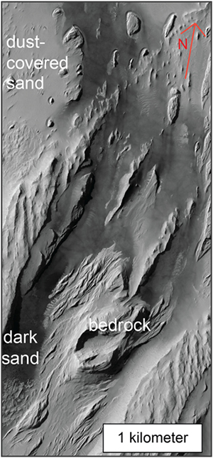
Figure: Sand deposits between outcrops of the enigmatic Medusae Fossae Formation (MFF). Image credit: NASA/JPL/University of Arizona.
I’m an M.S. candiate in the department of Earth and Planetary Sciences, studying Martian sand.
On Earth, loose sediment, like gravel, sand, and dust, is transported by wind and water. Sand is plentiful on Earth—for example, on beaches or in riverbeds. We can trace loose sediment back to its source by analyzing the mineralogy, geochemistry, and sediment pathways of sediments and potential bedrock sources.
On Mars, the story is more complicated. Water did play a role in transporting sediment on Mars about four billion years ago, but since then, Mars has dried up. Present-day Mars is a desert planet on which landscape change is driven by aeolian (wind) processes—a slow process, especially on Mars. The thicker the atmosphere, the more easily sand is entrained, and less forceful wind is required to entrain sand. The Martian atmosphere is very thin, and high wind speeds are required to move Martian sand. However, because of the thin atmosphere, once sand is entrained by the wind it should move quickly, bouncing along the surface, being reduced in grain-size to even smaller particles.
Both the high wind speeds and the fact that sand should break down to smaller particles quickly once entrained tell us we shouldn’t see much sand on Mars—rather, we should see a lot of very fine particles. We do see fine particles, but we also see sand—scattered all over the Martian globe. We do not, however, see obvious sources for most of this sand (e.g., nearby bedrock). This conundrum begs the questions: how did sand reach all latitudes on Mars? If sand is not eroded from local bedrock, then how could it travel so far under Martian conditions? One hypothesis that, if valid, would obviate the need for long-distance sand transport is that widespread Martian volcaniclastic deposits—materials erupted from volcanoes that are entrained by the wind across long distances before settling out—are eroding to loose sediment, the sand-sized portion of which collects as dune fields or rippled sand sheets. My research investigates this hypothesis by studying sand deposit distribution around one hypothesized volcaniclastic deposit, the Medusae Fossae Formation (MFF). I’m using high-resolution images to study the relationship between the sand and the MFF. Stay tuned for results down the road.
Publications
- Sullivan, W.A., Boyd, A.S., and Monz, M.E., 2013, Strain localization in homogeneous granite near the brittle-ductile transition. A case study of the Kellyland fault zone, Maine, USA: Journal of Structural Geology, v. 56, p. 70-88.
Conference Abstracts
- Boyd, A. S., and D. M. Burr (2018) Investigating the sources and origins of dark sand in Aeolis Dora, Mars: Evidence for local dark sediment production. Lunar Planet. Sci. XLIX, The Woodlands, TX, Mar 19-23, Abstract 2734.
- Burr, D. M., Jacobsen, R. E., Lefort, A., Borden, R. M., Boyd, A. S., and Peel, S. E., 2017, Update on mapping of the Aeolis Dorsa Region, Mars: Discovering even more diversity in this inverted landscape. 3rd Planetary Data Workshop, Abstract 7010.
- Boyd, A. S., Burr, D. M., and Tran, L. T., 2017, Investigating sand sources and origins in Aeolis Dorsa, Mars, via quantitative GIS techniques. 5th International Planetary Dunes Workshop, Abstract 3016.
- Boyd, A. S., and Burr, D. M., 2017, Constraining sources of sand in the Aeolis Dorsa region, Mars, via sand dune morphologies and sand distributions. 48th Annual Lunar and Planetary Science Conference, Abstract 1463.
- Boyd, A. S., and Burr, D. M., 2016, Mapping of sand types and dune morphologies in the Aeolis Dorsa region, western Medusae Fossae Formation, Mars. Annual Planetary Mappers’ Meeting, Abstract 7033.
- Burr, D. M., Jacobsen, R. E., Lefort, A., Borden, R. M., and Boyd, A. S., 2016, Continuing to characterize the history of a diverse inverted landscape: mapping of the Aeolis Dorsa region, Mars. Annual Planetary Mappers’ Meeting, Abstract 7013.
- Sullivan, W. A., Monz, M. E., and Boyd, A. S., 2015, Long-term strength contrasts between texturally similar fault rocks across a large strike-slip shear zone: A case study of the Kellyland fault zone, eastern Maine. Geological Society of America Abstracts with Programs, vol. 47, no. 7, p. 290.
- Monz, M. E., Boyd, A. S., and Sullivan, W. A., 2013, Deformation mechanisms in three protoliths across the Kellyland fault zone, Washington County, Maine. Geological Society of America Abstracts with Programs, vol. 45, no. 7, p. 598.
- Sullivan, W. A., Boyd, A. S., and Monz, M. E., 2013, Strain localization in homogenous granitic rocks at the brittle-plastic transition: a case study of the Kellyland fault zone, Washington County, ME. Geological Society of America Abstracts with Programs, vol. 45, no. 1, p. 88.
- Boyd, A. S., Monz, M. E., and Sullivan, W. A., 2012, Origin of mylonites and ultramylonites in the Kellyland fault zone, Washington County, ME. Geological Society of America Abstracts with Programs, vol. 44, no. 7, p. 127.